How to Reach the Most Popular Lagunas of San Pedro de Atacama
When we visited San Pedro de Atacama in 2024, we struggled to find accurate information about the dozens of lagunas nearby. There is no central park system; each laguna is managed by its local community. The rules and regulations are different for each laguna, and not all of the information is available online. Until now!
Here, we have listed the most popular lagunas that can be visited from San Pedro de Atacama. We did not personally visit each one; if you have, and would like to add to our descriptions, please leave a comment. If you would like to read about our personal experience in the Atacama, check out this post.
Skip to a laguna
What is a Laguna?
A laguna is a body of water that is cut off from other water. Considering that San Pedro de Atacama is one of the driest cities on earth, we were surprised by how many lagunas we found there! In the Atacama, most of these lagunas have a high salt concentration. We’re not talking about your regular table salt here; the salt flats of the Atacama are rich in lithium, borax, and potassium.
The Ecosystem of a Laguna
Over time, minerals from the nearby Andes and Domeyko mountain ranges washed down onto the flat plains below. There is no outlet for the water, so it remains here and slowly evaporates. The minerals do not evaporate with the water and instead are left behind to combine into salt crystals. These salt deposits for a salar, or salt flat. The Salar de Atacama is the third largest salt flat in the world. There are other salt flats nearby, such as the Salars de Aguas Caliente, Quisquiro, and Talar.
The salt concentrations in some areas are so high that it is prohibitive to many life forms. One organism that has adapted to the condition is the brine shrimp. This has attracted flamingos to the area, who feed on the brine shrimp. The high concentration of salt in the shrimp are what give the flamingos their pink color. There are also microbes, tiny, simple life forms that interact with the minerals and create different stratum and deposits in the salt. This is one of the factors that gives each laguna its unique color.
Laguna Management
Many of the lagunas are part of Los Flamencos National Reserve, a group of nature preserves spread around the San Pedro de Atacama area. However, there is not one central place to find information about them. We have done our best to list the most popular lagunas below, and update info as we are able.
The locals communities surrounding San Pedro de Atacama manage the lagunas within their jurisdicition. Some lagunas have a manned ticket booth and gate with entry fees, registration requirements, and mandatory info briefings. The gatekeepers’ English is limited at best, so it is very helpful to know what to expect before getting there. This can be confusing because each laguna is managed in a different way.
A friendly reminder: all of the lagunas are very exposed to the sun and some are at high altitudes. Wear a hat and drink plenty of water!
Laguna Cejar & Laguna Piedra
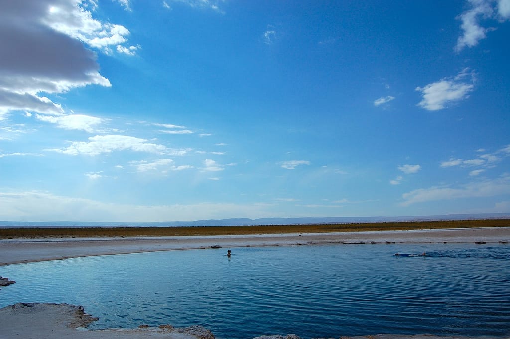
Location: Lagunas Cejar and Piedra are located within the Salar de Atacama, and managed by the Comunidad de Solor.
Driving Time from San Pedro de Atacama: 30 minutes
Operating Hours:
9 AM – 12 PM for general public
2 PM – 5 PM for guided tours
closed Tuesday
Entry fee: 15,000 CLP
How to Pay: online with a credit card
Website: www.cejarypiedra.com
Description:
The main attraction here is Laguna Piedra, one of the few salt lagunas in the area that allows swimming. Laguna Cejar is a great place for wildlife viewing. These Lagunas are partially natural, but also encouraged by the atacameño people who dug trenches to channel water, an Andean technique known as “regar el agua”. There is an interpretive loop trail that starts at the welcome center, passes Laguna Cejar, and then onto Laguna Piedra where you can swim. The final stop are the facilities with bathrooms and an outdoor shower to rinse off the salt.
How to Get Here:
Take Route CH-23 south out of San Pedro de Atacama about 10 miles. There is a right hand turn onto a dirt road. The sign indicates Laguna Tebenquiche, but Lagunas Cejar and Piedra are along this road as well. The dirt road starts off in very good condition. About five miles down the road there is a left hand turn. After this the road is more bumpy but still manageable with an SUV. In 1.5 miles there is a fork in the road, take the right hand fork to go to Laguna Cejar.
Lagunas Escondidas de Baltinache
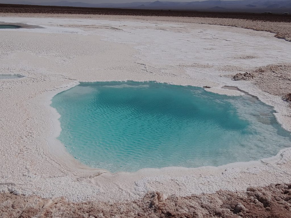
Location: Lagunas Escondidas de Baltinache are located in the Llano de la Paciencia and managed by the Comunidad de Coyo.
Driving Time from San Pedro de Atacama: 1½ hours
Operating Hours:
winter 10AM – 5PM
spring 9:30AM – 7:30PM
summer 9AM-8PM
Entry fee: 10,000 CLP
How to Pay: at the ticket booth with cash
Website: www.coyo.cl & www.baltinache.com
Description:
The Lagunas Escondidas de Baltinache contain seven lagunas that are linked underground. Their salt water content is similar to the Dead Sea, and about 7 times more than ocean water. The high salinity lowers the water’s specific gravity, allowing a person to easily float. There are restroom facilities here but no showers. It is recommended to bring extra water to rinse off with after swimming in the lagunas.
How to Get Here:
Head west out of San Pedro de Atacama for 8.5 miles until you reach road B-241. Follow this road south for 28 miles until you reach the ranger station. B-241 is a very rough dirt road where flat tires are a distinct possibility – be prepared.
Laguna Tebenquiche & Los Ojos del Salar

Location: Laguna Tebenquiche and Los Ojos del Salar are located within the Salar de Atacama, and managed by the Comunidad de Coyo.
Driving Time from San Pedro de Atacama: 1 hour
Operating Hours:
winter 10AM – 5PM
spring 9:30AM – 7:30PM
summer 9AM-8PM
Entry fee: 5,000 CLP
How to Pay: at the ticket booth with cash
Website: www.coyo.cl & www.tebenquiche.com
Description:
This site contains two unique environments. First, just outside of the ticket booth, are Los Ojos del Salar. These two round ponds contain (relatively) fresh water, a rarity on the salt flats! The water is much deeper than the water in the salt lagoons. The deep, still water gives a beautiful blue reflection of the sky; this combined with their round shape earned them their nickname, the Eyes of the Salt Flat. At one time, this was a popular swimming place, but that is no longer allowed in order to preserve the ecosystem.
The second area you can visit here is the Laguna Tebenquiche. This lagoon covers an area of 5 square miles. In the winter, the water covers most of this area, but in the summer the water evaporates. What remains is a thick white crust that looks like snow. Very little can survive in this harsh environment, but one life form has found a way: halophilic microorganisms. These microscopic creatures are thought to be some of the first life on earth, billions of years ago.
How to Get Here:
Take Route CH-23 south out of San Pedro de Atacama about 10 miles. There is a right hand turn to a dirt road, with a sign for Laguna Tebenquiche. The dirt road starts off in very good condition. About five miles down the road there is a left hand turn. After this the road is more bumpy but still manageable with an SUV. In 1.5 miles there is a fork in the road, take the left hand fork and continue south. The entry gate is about 7 miles further at the end of the road.
Laguna Chaxa
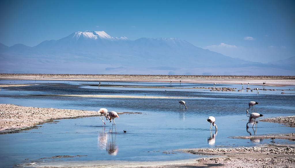
Location: Laguna Chaxa is located within the Salar de Atacama, outside of the town of Toconao.
Driving Time from San Pedro de Atacama: 1 hour
Operating Hours: daily 8AM-7PM
Entry fee: 8,000 CLP
How to Pay: at the ticket gate with cash or online with a credit card
Website: www.comunidadtococao.cl
Description:
Laguna Chaxa is known for its large population of flamingos. There is an interpretive loop trail about 0.25 miles long that takes you through the salt flat. There are signs about the ecology and geology of the region. The trail leads to an open area in front of the lagoon where you can view the flamingos. There is also a shorter trail leading straight to the flamingos, if you prefer. Plan to spend between 1-2 hours walking the trail and taking photographs.
How to Get Here:
Take Route CH-23 southeast through the town of Toconao. There is a right hand turn about 2 miles past Toconao to a well-maintained dirt road. Laguna Chaxa is 13 miles away at the end of the dirt road.
Laguna Barros Negros
Location: Laguna Barros Negros is located in the eastern part of the Salar de Atacama.
Driving Time from San Pedro de Atacama: 1 hour
Operating Hours: all day
Entry fee: none
How to Pay: N/A
Website: none
Description:
Laguna Barros Negros is about 1 mile south of Laguna Chaxa. While it is quite close by, the microorganisms there vary substantially, resulting in colored strata of salt deposits. Usually, a yellow/orange layer on top, a green layer in the middle, and sometimes a purple layer on the bottom.
How to Get Here:
Take Route CH-23 southeast through the town of Toconao. There is a right hand turn about 2 miles past Toconao to a well-maintained dirt road. The entry to Laguna Chaxa is 13 miles away at the end of the dirt road. You will need to walk the remaining mile to Laguna Barros Negros. Additionally there are off-road tracks that lead to the southern end of Laguna Barros Negros.
Laguna Puilar
Location: Laguna Puilar is located in the eastern part of the Salar de Atacama.
Driving Time from San Pedro de Atacama: 1 hour
Operating Hours: all day
Entry fee: none
How to Pay: N/A
Website: none
Description:
Laguna Puilar is about 1 mile northeast of Laguna Chaxa. Here you can see the famous Andean flamingos and observe the unique environment created by the microbial activity on the salt flat. Many scientific studies have been held here to help us understand what primordial life may have been like.
How to Get Here:
Take Route CH-23 southeast through the town of Toconao. There is a right hand turn about 2 miles past Toconao to a well-maintained dirt road. The entry to Laguna Chaxa is 13 miles away at the end of the dirt road. You will need to walk the remaining mile to Laguna Puilar.
Lagunas Interna, Salada, and Saladita
Location: Lagunas Interna, Salada, and Saladita are in the far southeast section of the Salar de Atacama.
Driving Time from San Pedro de Atacama:
Operating Hours: all day
Entry fee: none
How to Pay: N/A
Website: none
Description:
Lagunas Interna, Salada, and Saladita are three inter-connected lagunas of the Salar de Atacama. They are smaller, each being less than 50 acres. Despite sharing a water source below ground, they have different microbes, resulting in different colorations of their salt crystals. Flamingos have been known to nest in these areas.
How to Get Here:
From San Pedro de Atacama, follow Route 23-CH for 44 miles. Shortly after you pass the Tropic of Capricorn, you will turn right onto Route B-379, followed by a left onto B-39. After 14 miles, you will reach the final turn, a right onto a rough dirt road. You will need a 4×4 off-road vehicle, good driving skills, and a reliable sense of direction. It is possible to drive yourself but it is recommended to book a guide in San Pedro de Atacama.
Laguna Tuyajto

Location: Laguna Tuyajto is located in the altiplano area south of the Miñiques Volcano, just west of the Argentine border.
Driving Time from San Pedro de Atacama: 2.5 hours
Operating Hours: all day
Entry fee: Free
How to Pay: none
Website: none
Description:
Laguna Tuyajto is a beautiful turquoise altiplanic salt lake located between the mountains of Tuyajto to the north, Incahuasi to the southeast, and Medano to the southwest. The lake is at an altitude of 13,160 feet. It is a medium-sized lake, between ⅔ and 1 square mile, but only two feet deep. During the winter it partially freezes over.
How to Get Here:
Take Route CH-23 south out of San Pedro de Atacama about 100 miles. You will pass through the town of Socaire and the Piedras Rojas site. The Laguna Tuyajto viewpoint is a parking lot on the side of the road.
Laguna Salar de Agua Calientes Sur & Piedras Rojas

Location: Laguna Salar de Agua Calientes Sur & Piedras Rojas are located in the altiplano area south of the Miñiques Volcano. The site is managed by the town of Socaire, Chile.
Driving Time from San Pedro de Atacama: 2½ hours
Operating Hours: daily 9AM – 6PM
Entry fee: 10,000 CLP
How to Pay: pre-register with a credit card on the website and claim your ticket at the ranger station in Socaire. Note that you must arrive at the station in Socaire one hour BEFORE the time slot you reserved online.
Website: www.socairechile.cl
Description:
The Laguna Salar de Aguas Calientes Sur is a beautiful laguna set within a salt flat at 13,750 feet. Spread out in front of the laguna on the northwestern end is a huge expanse of flat reddish stones. These rocks get their color from the oxidation of the iron found in them, and the color in turn is what gives the site its name: Piedras Rojas, or Red Rocks.
This site has been developed with a parking lot, restrooms, and a loop trail that winds over the rocks and down to the laguna’s edge. The path is well-marked and visitors are not allowed to stray from it. The loop is only about 1½ miles long, but the fierce winds and high altitude means the path usually takes about an hour to walk. The terrain is mostly flat and not technically challenging.
How to Get Here:
Head south on Route 23-CH for 54 miles, about 1½ hours driving time. You will arrive at the town of Socaire. Here you must stop at the Recepción de Turistas to get a ticket that you will present at the station at Piedras Rojas. The building is a brown cargo container near the entrance of Socaire. You will need to have the reservation number or QR code downloaded.
From the Recepción de Turistas in Socaire, continue south for another 38 miles on Route 23-CH. You should see a sign indicating Piedras Rojas and the Salar de Agua Calientes. Pull into the parking lot and bring the ticket you received in Socaire to the brick ranger station at the trailhead.
Technically your ticket gives you a check in time, but the rangers don’t seem to be worried about this as long as you stopped in Socaire properly. They may tease you about being late but just tell them you stopped to take pictures!
Lagunas Miñiques & Miscanti

Location: Lagunas Miñiques & Miscanti are located in the altiplano area north of the Minique Volcano. The site is managed by the town of Socaire, Chile.
Driving Time from San Pedro de Atacama: 2 hours
Operating Hours: daily 9AM – 6PM
Entry fee: 10,000 CLP
How to Pay: pre-register with a credit card on the website and claim your ticket at the ranger station in Sociare. Note that you must arrive at the station in Socaire one hour BEFORE the time slot you reserved online.
Website: www.socairechile.cl
Description:
Lagunas Miscanti and Miñiques are two altiplanic lakes fed by runoff from the Miñiques volcano and Cerro Miscanti. The lagunas are separated by a lava flow from the Pleistocene era. Laguna Miscanti covers an area of over five square miles, one of the biggest bodies of water in the Atacama Altiplano region. Laguna Miñiques is smaller, at just over ½ square miles. These lagunas are important areas for wildlife. Vicuñas are commonly seen here, as are birds such as flamingos, Andean seagull, and horned coots are also found here.
How to Get Here:
Head south on Route 23-CH for 54 miles, about 1½ hours driving time. You will arrive at the town of Socaire. Here you must stop at the Recepción de Turistas to get a ticket that you will present at the station at Piedras Rojas. The building is a brown cargo container near the entrance of Socaire. You will need to have the reservation number or QR code downloaded.
From the Recepción de Turistas in Socaire, continue south for another 13 miles on Route 23-CH. You should see a sign indicating a dirt road leading to Lagunas Miscanti and Miñiques. Take this road southeast four miles to the ranger station. Fair warning, it is a very bumpy dirt road with several switchbacks heading up into the mountains. At the ranger station, someone will come out to check your ticket, and then direct you on to the lagunas.
Technically your ticket gives you a check in time, but the rangers don’t seem to be worried about this as long as you stopped in Socaire properly. They may tease you about being late but just tell them you stopped to take pictures!
If you combine this with a tour visiting Piedras Rojas first, you will be returning north on Route 23-CH. The turn off for the dirt road to Lagunas Miscanti and Miñiques is 26 miles from Piedras Rojas.
Laguna Salar de Tara
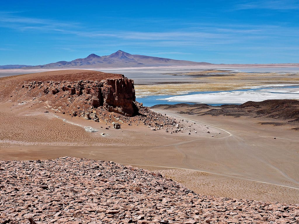
Location: Laguna Salar de Tara is set within the crater of the Vilama Volcano, near the borders of Bolivia and Argentina.
Driving Time from San Pedro de Atacama:
Operating Hours: all day
Entry fee: free
How to Pay: N/A
Website: none
Description:
The Salar de Tara is a 18 square mile salt flat located at 14,000 feet. On one side of the salar are enormous ash outcroppings that were once part of a large volcanic caldera, nicknamed the Cathedral of Tara. The Salar de Tara provides a habitat for many rare species, including Darwin’s rhea, the Andean fox, and all three species of flamingos found in Chile.
How to Get Here:
From San Pedro de Atacama, head east on Route 27-CH for 63 miles. Turn left onto an unmarked dirt road. The road is basically a track left by others, so you will need a 4×4 off-road vehicle, good driving skills, and a reliable sense of direction. It is possible to drive yourself but it is recommended to book with an independent tour company in San Pedro de Atacama.
Puritama Hot Springs
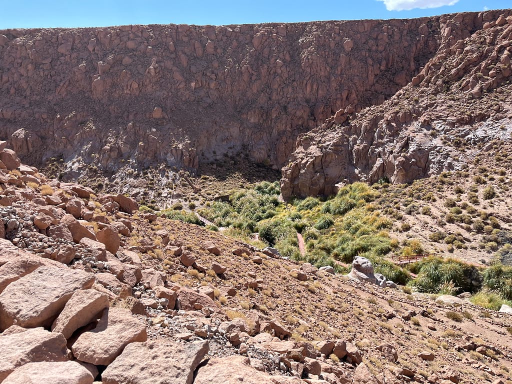
Location: The Puritama Hot Springs are located along the road to El Tatio volcano. It is privately managed by Explora.
Driving Time from San Pedro de Atacama: 30 minutes
Operating Hours: daily 9:30AM – 7PM, reserved in 3 time slots
Entry fee: 35,000 CLP
How to Pay: online with a credit card
Website: www.termasdepuritama.cl
Description:
The Puritama Hot Springs is a spa resort operated by Explora. The hot springs contain minerals, including calcium, magnesium, sodium, and boron, that revitalize the body and the mind. Explora manages the area for tourism while conserving the ecosystem of the enclosing canyon. They have constructed a series of boardwalks to reach the pools. There are also changing rooms and restrooms centrally located.
How to Get Here:
From San Pedro de Atacama, head north on Route B-245 for 18 miles. You will see a sign and a ticket booth on the left side of the road.
